A Neatline is the outermost drawn line surrounding a map. It defines the height and width of the map and usually constrains the cartographic images. The Neatline is a newsletter for the Texas Map Society (1998-Present).
Current Issue
Texas Map Society Newsletter – The Neatline, Issue 40, Fall 2025
Previous Issues
- Issue 41 – Spring 2026
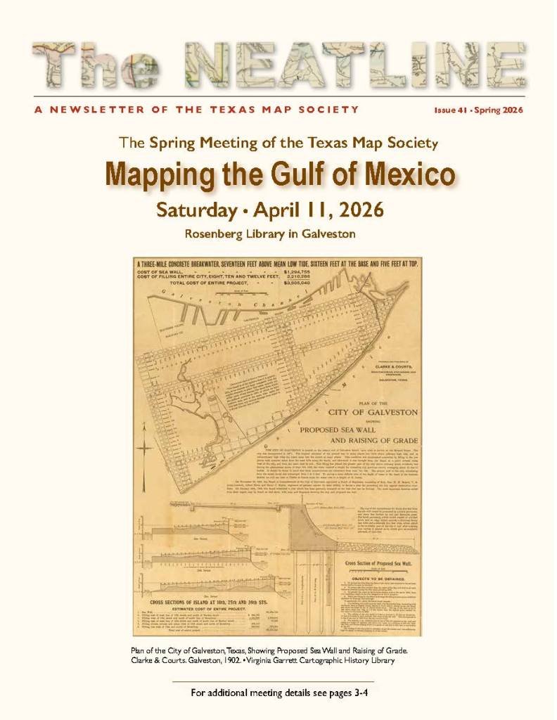
- Front cover – Plan of the City of Galveston, Texas, Showing Proposed Sea Wall and Raising of Grade. Clarke & Courts. Galveston, 1902. • Virginia Garrett Cartographic History Library
- Program for Spring 2026 TMS meeting – Mapping the Gulf of Mexico -in Galveston, TX, p. 1-4, including 1. Insulae Americanae in Oceano Septentrionale, cum Terris adiacentibus, Joannes Janssonius. Amsterdam, 1660, 2. Les Costes aux Environs de la Riviere de Misisipi, Nicholas de Fer. Paris, 1705, 3. A New & Accurate Map of Mexico or New Spain… , Emanuel Bowen. London, 1747
- Article – TMS Graphics Designer Carol Lehman is Retiring – by David Finfrock, p.4
- Save The Date – 2026 Virginia Garrett Lectures Frozen Frontiers, Chart of the South Polar Region, J. G. Bartholomew, 1905, p.5
- Review of the Fall 2025 TMS Meeting in Arlington – by David Finfrock, p.6-7, Including A New Map of the World from the Latest Observations Most Humbly Inscribed to his Royal Highness George Prince of Wales, John Senex, London, 1721
- My Favorite Map by Madeline Lowry – Antarctic Conjecture and Speculative Geography, p.8-9, including 1. Carte des Terres Australes Comprises entre le Tropique du Capricorne et le Pole Antarctique, Philippe Buache, 1757, 2. Typus Orbus Terrarum, Abraham Ortelius, 1570 (1588)
- Article – Fifteenth Century Ship Building of Noah’s Ark by Martin M. van Brauman, p. 10-11, ARCHA-NOE, from the 1493 Latin edition of the Nuremberg Chronicle
- Article – UTA Special Collections presents Atlas of Champions by Evan Spence, p.12-13, including 1. Fisikalna Karta Hrvatske, Slavonije, e Dalmacije, Karlo Herdlickza and F. Köke, 1900, 2. A Map of England from the latest observations, John Senex, 1721, 3. Map of the Gold Coast including the British Mandate of Togoland, War Office and Edward Stanford, 1911, 4. Tabula Moderna et Nova Hispanie, Martin Waldseemüller, 1513, 5. Carta Maritima del Reyno de Tierra Firme u Castilla del Oro comprehende del istmo de Panama…, Juan López, 1785, 6. FIFA World Cup 2022, by Fédération Internationale de Football Association
- Article – Cloth Escape Maps of the European Theatre During WWII By Martin M. van Brauman, including eight maps of European countries used by US servicemen
- Article – Map of the San Jacinto Battlefield by David Finfrock and the staff of the GLO, including San Jacinto Battle-Ground, H. Yoakum, 1856
- Issue 40 – Fall 2025
- Front cover – A General Chart of the Sea Coast of Europe, Africa, & America. Herman Moll. Published in Josiah Burchett’s A Complete History of the Most Remarkable Transactions at Sea, 1720, London
- Program for Fall 2025 TMS meeting – Dianne Powell Tribute – Collecting In and About Texas, in Arlington, TX, p.1-4, Including 1. New Griechen land mit andern anstossenden Landern wie es zu unsern zeiten beschriben ist, Sebastian Munster, ca. 1550, 2. Mexico Regia et Celebris Hispaniae Novae Civitas (and) Cusco, Regni Peru in Novo Orbe Caput, Georg Braun, 1572, 3. Planisphere Terrestre Suivant les nouvelle Observations des Astronomes Dressee et presente Roy Tres Chretien par Mr. Cassini le Fils, Pieter van der Aa, 1713 , 4. A New Map of the World from the Latest Observations Most Humbly Inscribed to his Royal Highness George Prince of Wales, John Senex, 1721, 5. Le Nouveau Mexique avec la partie Septentrionale de l’Ancien ou de la Nouvelle Espagne, Rigobert Bonne, 1780
- Save The Date – 2025 Virginia Garrett Lectures, p.5, The Antarctic Regions, Stanford’s Geographic Establishment, London, 1913., p.5
- Article – The Intersection of Cartography and Needlework by David Finfrock – Needlework Compass Rose and Map of Texas illustrating average annual precipitation, p. 6-7
- Book Review – TMS Board Members Publish Major New Work on Texas Cartographic History by James Harkins and Brian Stauffer – New GLO book Texas Takes Shape, p.8
- My Favorite Map by George L. Butler, Jr. – Karte des Staates Louisiana. Nebst Angabe der Höhenverhältnisse und der Deutschen Ansiedlungen. Herausgegeben von der Deutschen Gesellschaft von New Orleans, La. U.S. 1895. (Map of the State of Louisiana. Including indication of elevation conditions and German settlements. Published by the German Society of New Orleans, Louisiana, U.S. 1895.), p.9-11
- Article – Beautiful Biblical Maps Resulting from the Dutch Golden Age by Martin M. van Brauman – Including WERELDKAART, Kleine Keurkaarten, published by Jacob and Hendrick Keur, Amsterdam, 1748, along with four maps of the Holy Land, p.12-17
- New to the Map Room – Recent Acquisitions at UTA by Madeline Lowry – including 1. Novissima et Perfectissima Africae Descriptio ex formis Caroli Allard, Carel Allard, ca. 1696, 2. Africa Nova Tabula, Pietro Todeschi, ca. 1670, 3. Texas showing counties, cities, towns, villages, and post offices, railways with stations and distances between stations, George F. Cram, 1940, 4. Carta Dell’ Oceano Australe Secondo R. Kiepert e traccia della Spedizione Antarctica Italiano proposta da G. Bove Sott.e di Vascello, Giacomo Bove,
- 1880, 5. [Japanese Map of the Antarctic with 1957 Calendar], Sogensha Co. Ltd., 1957, 6. Reconnaissance Map King Edward VII Land. The Northern Part of Marie Byrd Land, American Geographical Society, 1933, 7. The Illustrated Atlas, and Modern History of the World, Geographical, Political, Commercial & Statistical, Robert Montgomery Martin and John Tallis, 1851, p.18-20
- Article – Texas General Land Office Unveils New Antique Surveying Instruments Exhibit By Krista Schreiber, p.21-24
- Announcement of 2025 Save Texas History Symposium, p. 25
- Announcement of new reference section at Old World Auctions, p.26
- Article – Request for Map Collaboration by David Finfrock, p.26
- Issue 39 – Spring 2025
- Front cover – Preliminary Sketch of Galveston Bay Texas, J.M. Wampler & T.A. Craven, published by U.S. Coast Survey, A.D. Bache Superintendent, 1852, Washington, D.C.
- Announcement of cancellation of Spring 2025 TMS meeting planned for Galveston, TX, p.1-2
- Article – Making Historic Documents Come to Life through GLO StoryMapping By Lynnette Cen – George P. Bush, Lance McIlhany, Mark Conway, and James Harkins, Energy Map of Texas, 2020, Austin., and other maps and images, p.3-6
- Review of presentations at the Fall 2024 Virginia Garrett Lectures on Charting Cosmic Visions, p.7-9
- Save the Date announcement for the Fall 2026 Virginia Garrett Lectures in Arlington, TX on the exploration and mapping of Antarctica, p. 10
- Article – The Genesis of the US-Mexican War of 1846-1848 by David Finfrock – Map of the State of Texas, From the Latest Authorities, by J.H. Young, Cowperthwait, DeSilver and Butler. 1854, Philadelphia., and other maps and images of the Palo Alto Battlefield in south Texas, p. 11-13
- My Favorite Map by David Finfrock – War Department Weather Map, Signal Service, U.S. Army. Washington, D.C., p.14-15
- Article – Discovering Antarctica from 1820 to 1845 through Maps and their Visuals of Place by Candace Carlisle Vilas – 1. No. 6, Circumjacent the South Pole. Engraved by J&C Walker. Published by Baldwin & Cradock, 47 Paternoster Row, June 1831., 2. No. 6, Circumjacent the South Pole. Engraved by J&C Walker. Published by the Society for the Diffusion of Useful Knowledge, 1842., and 3. No. 6, Circumjacent the South Pole. Engraved by J&C Walker, 1877., p.16-19
- Article – Sixteenth Central Travel Maps with the Holy Scriptures by Martin M. van Brauman – DIE GANZE WELT IN EIN KLEEBERBLAT/WELCHS IST DER STADT HANOVER MEINES LIEBEN VATHERLANDES WAPEN (THE WHOLE WORLD IN A CLOVERLEAF/ WHICH IS THE COAT OF ARMS OF THE CITY OF HANNOVER MY DEAR PATRIMONY), 1587, Wittenburg, and five additional 16th century maps, p.20-23
- Obituary of Dianne Powell, p.24-25
- Issue 38 – Fall 2024
- Front cover – Map of Southern Texas. Henry H. Hardesty. Published in Hardesty’s Historical and Geographic Encyclopedia, 1883, Chicago.
- Program for Fall 2024 meeting of the TMS in San Antonio, TX on Frontiers and Borderlands of Texas and the Greater Southwest, in conjunction with the Society for the History of Discoveries, p.1-5
- Review of presentations at the Spring 2024 meeting of the TMS in Austin, TX, p.6-8
- Article – Medieval Cityscapes and Landscapes with Different Perspectives by Martin M. van Brauman – Including 5 medieval images, p.9-13
- Announcement of the Fall 2024 Virginia Garret Lectures on Charting Cosmic Visions in Arlington, TX, p.13
- Article – New Acquisition for UTA Special Collections by David Finfrock (and additional text from Barry Lawrence Ruderman – Japanaese world map titled Kaisei Chikyu Bankoku sankai yochi zenzu setsu (Revised map of all countries on the globe/ Map of the world and its mountains and oceans), Edo & Osaka / 1785 (1834), p.14-15
- My Favorite Map by David Finfrock – Soviet Army Map of North Texas – General Staff – Dallas. General Staff of the Soviet Armed Forces. Published as No.1-14-G in Russian military atlas, 1985, Moscow, p.16-17
- Announcement of Mapping the American Sea, A Cartographic History of the Gulf of Mexico – exhibit at the Tampa Bay History Center, p.18
- Article – Former U.S. Ambassador to Qatar Chase Untermeyer Donates Maps to the GLO Archive by Patrick Walsh – Including 8 recent map donations, p.19-21
- Article – Land, Lawyers, and Gamblers: Nineteenth-Century Texas History, as Told by a Map of San Jacinto County by Frank Mace – San Jacinto County, General Land Office, 1889, Austin, along with other maps and images, p.22-29
- Article – UTA Special Collections Welcomes New Director and Cartographic Archivist by Evan Spencer – Introduction of new UTA Special Collections Director Kera Newby and new Cartographic Archivist Madeline Lowry, p.30
- Obituary for Marvin Applewhite, p.31
- Issue 37 – Spring 2024
- Front cover – Texas. Thomas Gamaliel Bradford. Published in A Comprehensive Atlas (4th edition), 1838, Boston.
- Program for Spring 2024 meeting of the TMS in Austin, TX, p.2-5
- My Favorite Map by David Finfrock – Automobile Promotional Map of Texas – Texas-shaped map advertising Mohr Buick in Houston, p.6-7
- Article – Ben Huseman Retires from UTA Special Collections by Gerald Saxon, p.8
- Article – Imaginary Maps of Biblical Jerusalem by Martin M. van Brauman – Including six maps of Jerusalem, p. 9-15
- Article – UTA Libraries Receives Collection of Antique Maps of Antarctica by Andrew Branca, p. 16
- Announcement of GLO’s Save Texas History program, p.17
- Article – Best Laid Plat: Exploring Hybrid Urban Planning in Mexican Texas via Interactive StoryMap by Brian Stauffer – Including [Seth Ingram, Stephen F. Austin, and Samuel May Williams], Plan de la Villa de Austin, 1828 and other maps and images, p.18-25
- Announcement of the 2024 Ristow Prize in the History of Cartography, p.26
- Announcement of the 2024 Save Texas History symposium, p.27
- Announcement of call for papers for the fall 2024 TMS meeting in San Antonio, TX, p.28
- Obituary for Frank Harvey Holcomb, p.29
- Issue 36 – Fall 2023
- Front cover – A Geographically Correct Map of the State of Texas Published by the Texas & Pacific Railway Company, Woodward, Tiernan & Hale, 1878, St. Louis.
- Review of presentations at the Spring 2023 meeting of the TMS in Houston, TX, p.3
- My Favorite Map by David Finfrock – WBAP Promotional Maps, p.4-5
- Announcement of GLO’s Save Texas History program, p.6
- Article – GIS Maps and Education Outreach at the Texas General Land Office by Dr. Lila Rakoczy – p.7-9
- Book Review – Chet Van Duzer, Frames that Speak: Cartouches on Early Modern Maps (Leiden and Boston: Brill, 2023) p.10
- Article – The Changing Style of the Merian Jerusalem Map Variants During and After the Golden Age of Augsburg by Martin M. van Brauman – Including MATTHÄUS MERIAN (the Elder, 1593-1650), IERUSALEM, Frankfurt am Main, 1638 edition. Published in Neuwe Archontologia Cosmica, along with other Jerusalem maps and images, p.11-16
- Article – Oliver Cromwell’s own Atlas novus (1648-1655) By Aaron T. Pratt and Carl and Lily Pforzheimer, Joan Blaeu, ed., Theatrum orbis terrarum, sive Atlas novus, Vol. 5 (Amsterdam: Joan Blaeu, 1654)., p.17
- Article – The Iron Horse Reaches Texas – Charting the Railroad’s Arrival via Interactive StoryMap by Patrick Walsh – Including H. Groves, Map of the Republic of Texas shewing its division into Counties and Latest Improvements too, 1837, along with other railroad maps of Texas
- Issue 35 – Spring 2023
- Front cover – Bird’s Eye View of the City of Houston, Texas 1873. Lithograph by Augustus Koch. Published by J. J. Stoner, Madison, Wisconsin.
- Program for Spring 2023 meeting of the TMS in Houston, TX, Map of the State of Texas Published by the International and Gt. Northern Railroad., 1881., p.1-5
- Review of presentations at the Fall 2022 TMS meeting and the Fall 2022 Virginia Garrett Lectures on The Shifting Shapes of Texas, in Arlington, TX, Joint Meeting with the International Map Collectors Society. p.7
- My Favorite Map by Martin van Brauman – Christiaan van Adrichom’s Jerusalem – IERUSALEM, ET SUBURBIA EIUS, SICUT TEMPORE CHRISTI FLORUIT, CUM LOCIS IN QUIBUS CHRIST PASSUS EST: QUAE RELIGIOSE A CHRISTIANIS OBSERUATA ETIA NU VENERATIONI HABENTUR DESCRIPTA PER CHRISTIANUM ADRICHOM DELPHUM, [Jerusalem and its Surroundings As it Flourished During the Time of Jesus with the Places Where Christ Walked: Which Religious Christians Observe With Reverence Described by Christiaan Adrichom of Delft] COLONIAE AGRIPPINAE, ANNO CHRISTI 1584, Cartographer Christiaan van Adrichom, publisher Georg Braun, 1593, Cologne., p.9-10
- Article – The Mapmakers Who Made the 19th Century by Jon Dotson – p.11-15
- Article – Recording a Lifetime of Travel on a US County Map by David Finfrock, p.16
- Article – Charting Matagorda Island’s Military History in the GLO By Julia Bordelon – US Engineer Office, Calhoun County Rolled Sketch 11, Galveston, TX, and 2. : Eltea Armstrong, Calhoun Co., General Land Office, Austin, 1948., p.17-19
- Article – The First Separate Tribal Maps of the Holy Land by Christiaan van Adrichoma by Martin M. van Brauman – SITVS TERRAE PROMISSIONS SS BIBLIORVM INTELLIGENTIAM EXACTE APRIENS: PER CHRISTIANVM ADRICHOMIVM DELPHVM. (The disposition of the Promised Land Unlocking Exact Understanding of the Bible by Christiaan Adrichom), cartographer Christiaan Adrichom, publisher Georg Braun, 1593, Cologne., along with 11 separate tribal maps., p.20-27
- Article – Preserving the Ephemeral at the General Land Office – The Digitization of the John and Diana Cobb Map Collection by Patrick Walsh and James Harkins – The conservation and digitization of maps at the GLO, including William P. Blake, Geological Map of the route explored by Lieut. A.W. Whipple, Corps of Topl. Engrs. near the Parallel of 35° North Latitude from the Mississippi River to the Pacific Ocean, Baltimore: A. Hoen & Co., 1854., p.29-32
- Issue 34 – Fall 2022
- Front cover – Six different maps showing changing boundaries of Texas, including: 1. Girolamo Ruscelli, Nueva Hispania Tabula Nova, engraving with applied color on paper, from La Geografia di Ptolemi (Venice: Ruscelli, 1574., 2. Edward Wells, A New Map of North America Shewing Its Principal Divisions, Chief Cities, Townes, Rivers, Mountains &c.: Dedicated to His Highness William, of Glocester, engraving with applied color on paper, 36 x 49 cm., by Michael Burghers, from Edward Wells, A New Sett of Maps Both of Antient and Present Geography, Oxford, 1701., 3. John Senex after Guillaume Delisle, A map of Louisiana and of the River Mississipi, engraving and etching with applied color on paper, 49 x 58 cm., from Senex, A New General Atlas (London, D. Browne, 1721)., 4. J.H. Young & S. Augustus Mitchell, A New Map of Texas: with the Contiguous American & Mexican States., engraved transfer color lithograph on paper, 30 x 37 cm. (Philadelphia: S. Augustus Mitchell, 1836., 5. Samuel Augustus Mitchell, Sr., Map of Mexico, including Yucatan and Upper California, engraved transfer color lithograph on paper, 42 x 62 cm. (Philadelphia: S. Augustus Mitchell, 1846., 6. J. H. Colton & Co., Texas, engraved transfer color lithograph on paper, 35.8 x 28.5 cm. (New York: J. H. Colton & Co., 1855).
- Program for Fall 2022 Virginia Garrett Lectures on The Shifting Shapes of Texas, in Arlington, TX, Joint Meeting with the International Map Collectors Society, p.1-11
- Program for Fall 2022 TMS meeting in Arlington, TX, p.1-11
- My Favorite Map by Martin van Brauman – Monstrorum of the Sea and Land – DEERWUNDER UND SELTZAME THIER Wie die in den Ditnachtigen Landern/im Deer und auff dem Landt gefunden werden. [Wonders of the Sea and Rare Animals, as they are found in the midnight lands in the sea and on the land], published in Cosmographia Universalis, Basel, 1561., p.12-13
- Article – Mapping Drought by David Finfrock , p.14-16
- Article – The Mystery of the Boisseau Map Interpretation Under the City of David by Martin M. van Brauman – DESCRIPTION DE LA VILLA DE IERUSALEM AUEC LES NOMS DES SAINTS LIEUX OU ANTIQUITEZ QUI SONT VISITEZ PAR LES PELLERINS ET VOIAGEURS, Jean Boisseau, Paris, 1639, copperplate engraving, separate sheet map [73.5 x 24 cm]., p.17-20
- Article – Mapping Republic of Texas Empresario Colonies – Castro’s Colony and the Mercer Colony By: Patrick Walsh and James Harkins – Including 1. J. Kitian Potschiusky, Map of Castro’s Colony — Bexar District, San Antonio, 1851., and 2. Map of the Mercer Colony in Texas, New Orleans: Fishbourne’s Lithog., 1845., p.21-26
- Article – Henry Hannan, Texas Land Promoter by David Finfrock – Including original correspondence as well as three maps: 1. New Map of the State of Texas compiled from the latest authorities Revised and Corrected up to November 1876 by A.R. Roessler Civil and Mining Engineer; from J. Burke’s Almanac of 1878; New York., 2. A Geographically Correct Map of the State of Texas Published by the Texas & Pacific Railway Company;
- Woodward, Tiernan & Hale; 1878; St. Louis., and 3. A manuscript map of parts of Lynn and Garza Counties in Texas showing land plats, J. Hays, Fort Worth, 1878., p.27-30
- Issue 33 – Spring 2022
- Front cover – James H. Young and Samuel Augustus Mitchell, Sr., Map of Mexico, including Yucatan & Upper California, exhibiting the Chief Cities and Towns, the Principal Travelling Routes &c., steel engraved transfer chromolithograph on paper, 43.7 x 63.5 cm. (including borders) (Philadelphia: Au
- Announcement of cancellation of Spring 2022 TMS meeting, p.2
- Save The Date article for Fall 2022 Joint Virginia Garrett Lectures on The Shifting Shapes of Texas, in Arlington, TX, Joint Meeting with the International Map Collectors Society, p.1-5
- Review of presentations at the Fall 2021 meeting of the TMS, and at the Fall 2021 Virginia Garrett Lectures on Coordinating Cartographic Collections, in Arlington, TX, Meeting with the International Cartographic Association’s Commission on the History of Cartography, p.6-8
- Article – Antarctic Maps on Postage Stamps by David Finfrock, p.9-11
- Article – The de Bruyn Map Emphasized Jerusalem as a City of Churches By Martin M. van Brauman – Cornelis de Bruyn, Jerusalem, in his travel book, Reizen van Cornelis de Bruyn door de vermaardste deelen van Klein Asia, . . . Syria en Palestine, printed in Dutch by Henrik van Kroonevld (Henri de Kronevelt) in Delft, 1698., p.12-15
- Article – Mapmakers of the 19th Century by Jon Dotson, p.16-20
- Issue 32 – Fall 2021
- Front cover – Vincenzo Maria Coronelli, L’Africa divisa nelle sue Parti…, engraving with applied color on two sheets of paper, 61 x 45 cm., from Coronelli, Atlante Veneto, vol. 1 (Venice: Domenico Padoani, 1692).
- Program for Fall 2021 Virginia Garrett Lectures on Coordinating Cartographic Collections, in Arlington, TX, Joint Meeting with the International Cartographic Association’s Commission on the History of Cartography, p.1-6
- Program for Fall 2021 meeting of the TMS in Arlington, TX (with accompanying Exhibit Searching for Africa: The Map Collection of Dr. Jack Franke), p.1-6
- Review of presentations at the Virtual Spring 2021 meeting of the TMS hosted by Baylor University in Waco, TX, on Five Centuries of Mexican Maps, p.7-8
- My Favorite Map by David Finfrock – A large map of the contiguous United States assembled from license plates of each of the 48 states, p.9-11
- Article – History of Papermaking for Map Collectors by Marti Griggs, p.12-13
- Article – The Holy Land Maps in Hebrew and Latin from the Polyglot Bible by Benito Arias Montano by Martin M. van Brauman – Includes SACRAE GEOGRAPHIAE TABULAM EX ANTIQUISSIMORUM CUL TOP. FAMILIIS A MOSE PECENSITIS AD SACRORUM LIBROR: EXPLICANDOR COM MODITATEM ANTUUERPIAE IN PHILIPPI REGIS CATHOLICI GRATIA DESCRIBEBUT, Frankfurt am Main, 1696. Published in Tractatorum biblicorum hoc est variarum in diversas materias biblicas commentationum . . . Printer: Balthasar Christophor Wüsti. Copperplate engraving and various maps of the Toly Land., p.14-19
- Article – Mexico, California and Texas; United States; John F. Tallis & John Rapkin, London, 1851 By Texas General Land Office – Including two maps: 1. John F. Tallis, Mexico, California and Texas, J. Rapkin: London, 1851. And 2. John F. Tallis, United States, J. Rapkin: London, 1851., p.20-24
- Issue 31 – Spring 2021
- Front cover – Texas. David H. Burr, 1835.
- Program for Spring 2021 virtual meeting of the TMS in Waco, TX, p.1-3
- My Favorite Map by Ben Huseman – A Fanciful Chart of the West African Coast – Jan Huygen van Linschoten and Arnold Florent van Langren, Typus orarum maritimarum Guinae, Manicongo & Angolae ultra promontarium Bonae Spei [Maritime Chart of Guinea, Manicongo and Angola to the Cape of Good Hope], engraving with applied color on paper, from Jan Huygen van Linschoten, Itinerario, voyagie, ofte Ship-vaert (Amsterdam: Cornelis Claesz., 1596)., p.4-6
- Article – Energy Map of Texas from the Texas General Land Office, p.7-8
- Article – Organizing the Archives: The Land Districts of Texas by the GLO Staff, p.9-11
- Article – The Great Awakening: The First Separate Maps of the Tribes of Israel by Martin M. van Brauman – Includes maps of each of the 12 tribes of Israel, p.12-20
- Article – The American School Atlases of Sidney E. Morse by Walt Wilson – Including Sidney E. Morse’s System of Geography for the Use of Schools, 1846 Edition, and a number of maps of Texas, the United States and North America, p.21-25
- Article – Why Visit UTA? Recent Cartographic Acquisitions at the University of Texas at Arlington Libraries Special Collections by Ben Huseman – Including 1. Giacomo Gastaldi, Nueva Hispania Tabula Nova, copperplate engraving on paper, 13.5 x 17.5 cm., from La Geografia di Claudio Ptolomeo (Venice: Gastaldi, 1548). 2. After John Smith, Nova Virginia Tabula, engraving with applied color on paper, 38 x 48 cm. (Amsterdam: Blaeu, 1635). 3. Nicolaes Jz. Visscher, Americae Nova Descriptio, engraving with applied color on paper, 44.5 x 56.8 cm. (Amsterdam: Visscher, 1650). 4. A topographicall Description and Admeasurements of the Yland of Barbados in the West Indyaes…, engraving on paper, 38 x 51 cm., in Richard Ligon, A True & Exact History of the Island of Barbados (London: Henry Moseley, 1657). 5. Arias Montanus, Sacrae Geographiae Tabulam…, engraving on paper, 32.5 x 52 cm., in Tractatuum Biblicorum… (Frankfurt am Main: Wustius & Andrea, 1696). 6. Pieter van der Aa, America in praecipuus ipsius partes distributa…/ l’Amerique selon les Nouvelles Observations…, engraving with applied color on paper, 50.5 x 68.5 cm. (Leiden: Van der Aa, 1713). 7. Henry Popple, A Map of the British Empire in America with the French and Spanish Settlements adjacent thereto. / America Septentrionalis, engraving with applied color on paper, 52 x 51 cm. (London: Popple, 1733)., p.26-30
- Obituary – Dominick Cirincione, p.30
- TMS Members Share Their Thoughts: Member Survey Results By: Brenda McClurkin, p.31
- Issue 30 – Fall 2020
- Front cover – Official map of the city of Waco and Suburbs, Stephen Turner, C.E. (1891).
- Announcement of cancellation of 2020 Save Texas History symposium and Fall 2020 TMS meeting and postponement of 2020 Virginia Garrett Lectures until 2021, all due to COVID pandemic p.2-3
- Save The Date feature announcing planned Spring 2021 virtual meeting of the TMS in Waco, p.4-5
- My Favorite Map by Imre Demhardt – Snows of the Kilimanjaro and a Gargantuan Lake, featuring a “sketch map” by August Petermann: Skizze einer Karte eines Theils von Ost- und Central-Afrika mit Angabe der wahrscheinlichen Lage u. Ausdehnung des See’s von Uniamwesi, nebst Bezeichnung der Grenzen u. Wohnsitze der verschiedenen Völkersowie der Caravanen-Strassen nach dem Innern. Gestützt auf die Angaben zahlreicher Eingeborenen und muhammedanischer Reisenden […]. Maasstab 1:5.000.000 (= Sketch of a Map of a Part of East and Central Africa with indication of the probable location and extension of the lake of Uniamwesi, along with designation of the borders and residences of the various peoples as well as the caravan routes to the interior. Based on information from numerous natives and Muslim travelers […]. Scale 1:5,000,000). With two inset maps in 1:24 million on bottom left, the outer one showing Erhardt’s assumption of the lake, the inner one showing Petermann’s assumption., p.5-9
- Article – The GLO Archives in the Times of COVID-19 by the Archives and Records Staff at the Texas General Land Office. p.10-12
- Article – The American School Atlas of William B. Fowle By Walt Wilson – Atlas to Fowle’s Geography, Lincoln & Edmands, Boston, 1831., p.13-15
- Article – Experts at Texas A&M University-Corpus Christi’s Conrad Blucher Institute help the public understand spread of COVID-19 with analyses, predictions, and detailed maps By Dr. Davey Edwards Director of the Texas Spatial Reference Center – including maps such as State Confirmed Cases of COVID-19 as of 17 August 2020, p.16-20
- Article – The Lee R. Greenhouse and Flora E. Lazar Map Donation to UTA By Ben Huseman – Including 1. Martin Waldseemüller and Claudius Ptolemy, Decima Asiae Tabula, woodcut with applied color on paper, from Claudius Ptolemy, Geographia (Strassburg: Johann Schott, 1513)., 2. Chinae, olim Sinarum regionis, nova descriptio…, engraving with applied color on paper, from Abraham Ortelius, Theatro de la Tierra Universal… (Antwerp: Christophe Plantin, 1588 first Spanish edition; first published in Latin in 1584)., 3. Jodocus Hondius, Japonia, engraving with applied color on paper, Amsterdam, 1606., 4. Hendrik Hondius, Poli Arctici, et Circumiacentium Terrarum Descriptio Novissima, engraving with applied color on paper (Amsterdam: Hondius, 1636)., and 5. Frederik de Wit, [Polus Antarcticus] Terra Australis Incognita, engraving with applied color on paper, probably from Atlas contractus, sive Atlantis majoris compendium … (Amsterdam: Jansson Heirs, 1666)., p.21-24
- Issue 29 – Spring 2020
- Front cover – Map of Houston Heights, Harris County, Texas owned by the Omaha & South Texas Land Co., Houston, Texas, Boston: Forbes Co., 1891.
- Announcement of cancellation of planned Spring 2020 meeting in Houston due to COVID pandemic, p.2
- Review of presentations at the Fall 2019 meeting of the TMS in Alpine, TX, on Five Centuries of Mexican Maps, p.4-6
- My Favorite Map by Matthew Walter – Carte de la cote de L’Amerique sur la Ocean Pacifique Septentirional comprenant La Territoire de L’Oregon, les Californies, La Mer Vermeille, Partie des Terretoires de la Compagnie de la Baie d’Hudson et de L’Amerique Russe. Eugene Duflot de Mofras. Paris, 1844., p.7
- Article – Mapping Houston Heights – Houston’s First Suburb – Map of Houston Heights, Harris County, Texas owned by the Omaha & South Texas Land Co., Houston, Texas, Boston: Forbes Co., 1891., p.8-13
- Article – Coahuila y Texas: A Meeting Place – Including 1. Mapa de los Estados Unidos de Méjico, Segun lo organizado y definido por las varias actas del Congreso de dicha Republica: y construido por las mejores autoridades, New York: White, Gallaher, and White, 1828, 2. David H. Burr, Texas, New York: J. H. Colton and Co., 1833, 3. J. H. Young, A New Map of Texas with the Contiguous American & Mexican States, Philadelphia: S. Augustus Mitchell, 1835, 4. P. Desobry, Map of Texas shewing the grants in possession of the Colorado & Red River Land Company, New York: Colorado and Red River Land Company, ca. 1835, and 5. E.F. Lee, Map of Texas containing the latest Grants and Discoveries, Cincinnati: J.A. James & Co., 1836, p.14-15
- Article -A Cataloger’s Perspective: Mapping the World and Continents By Eliane Dotson, including many maps and map projections, p.16-23
- Article – The School Atlases of Samuel Augustus Mitchell, 1839-1851 by Walter E. Wilson – Including Mitchell’s School Atlas, (unrevised), 1841., Mitchell’s School Atlas, Second Revised Edition, 1848., and Mitchell’s School Atlas, Third Revised Edition, 1850., along with many maps of Texas and North America., p.24-29
- Article – Project to stabilize and display a 17th-century Dutch map at Ransom Center in Austin by Elizabeth Page – Nova totius terrarum orbis tabula, it is known as the Blaeu World Map and was created by Dutch cartographer Joan Blaeu in 1648., p.30-31
- Obituary for Hubert O. (Bert) Johnson, p.32
- Article – Putting Pandemics and the World in Perspective by Imre Demhardt
- Obituary for John Martin (Marty) Davis, Jr., p.33
- Issue 28 – Fall 2019
- Front cover – Theodore de Bry and Girolamo Benzoni, America Sive Novus Orbis Respectu Europaeorum Inferior Globi Terrestris Pars, engraving with applied color on paper, 32.5 x 39.5 cm., from Americae pars sexta sive historiae ab Hieronymo Bezono (Frankfurt am Main: De Bry, 1596).
- Program for Fall 2019 meeting of the TMS in Alpine, TX, on Five Centuries of Mexican Maps, p.1-4
- Review of presentations at the Spring 2019 meeting of the TMS in Dallas, TX, p.5-6
- My Favorite Map by Rachel DeShong – Map of the United States with the Contiguous British & Spanish Possessions. John Melish, Philadelphia, 1816., along with A New Chart of the World on Mercator’s Projection with the Tracks of the Most Celebrated & Recent Navigators by John Crane Dower. London, 1842, p.7-9
- Article – Texas General Land Office Acquires and Conserves Atlas of Maps Made by Captain Zebulon M. Pike by James Harkins – including 1. A Map of the Internal Provinces of New Spain 2. A Chart of the Internal Part of Louisiana 3. The First Part of Captn. Pike’s Chart of the Internal Part of Louisiana 4. Falls of St. Anthony 5. Map of the Mississippi River from its Source to the Mouth of the Missouri 6. A Sketch of the Vice Royalty exhibiting the several Provinces Provinces and its Aproximation [sic] to the Internal Provinces of New Spain, p.10-12
- Announcement of Save Texas History Symposium, p.13
- Article – The Land Districts of Texas By Alex Chiba, GLO Map Vault Team Leader – includes O.G. Kurio, Map of the State of Texas Showing Original Land Districts, Austin, General Land Office, 1891. p.14-16
- Article – The American School Atlases of Jesse Olney by Walter E. Wilson – includes Olney’s New and Improved School Atlas, 1837, and Olney’s School Atlas, 1841 along with numerous maps, p.17-23
- Book Review – Mapping Texas: A Cartographic Journey, 1561-1860, by John S. Wilson, with Sierra M. Wilson and Rachel DeShong. Maps from the Frances C. Poage Map Room of The Texas Collection at Baylor University, p.24
- Book Review – Civil War Taxes, a New Book by Marty Davis, p.24
- Announcement of the 2019 North Texas Book & Map Show, p.24
- Issue 27 – Spring 2019
- Front cover – Fred A. Jones and Bert Firmin, State of Texas Sectional Map Dallas and Tarrant Counties Sheet No.1, color lithograph on paper, 34.5 x 50.5 cm. (Dallas, Texas: Fred A. Jones, 1915).
- Program for Spring 2019 meeting of the TMS in Dallas, TX, p.1-4
- Review of presentations at the Fall 2018 meeting of the TMS and of the Virginia Garrett Lectures in Arlington, TX, p.5-7
- My Favorite Map by Dr. Brian Stauffer, GLO Spanish Translater – Antonio de Herrera y Tordesillas, Descripción de las Indias Occidentales, Amsterdam, 1622, Map #94850, Map Collection, Archives and Records Program, Texas General Land Office, Austin, TX., p.8-11
- Article – The State of Franklin by Eliane Dotson, p.12-15
- Article – The Growing Cartographic Collections at UT Arlington by Ben Huseman. Includes the following: 1. Martin Waldseemüller, Tabula Moderna Primae Partis Aphricae, woodcut engraving with applied color on paper, 41.5 x 57 cm., from Supplementum to Claudius Ptolemy, Geographiae (Strasbourg: Waldseemüller, 1513), 2. Girolamo Ruscelli, Nueva Hispania Tabula Nova, copperplate engraving with applied color on paper, 19 x 24.5 cm., from s (Venice: Ruscelli, 1574), 3. Abraham Ortelius, Africae Tabula Nova, copperplate engraving with applied color on paper, 37.7 x 50.6 cm., (Antwerp, probably between 1570-1581), 4. Jean Baptiste Bourguignon d’Anville, Afrique publiée sous les auspices de Monseigneur le duc d’Orléans, prémier Prince du Sang…, engraving with applied color on paper (two sheets joined), 99.06 x 98 cm., engraved by Guillaume Delahaye (Paris: d’Anville, 1749), 6. A. H. Dufour, Amerque du Nord, engraved transfer
- Article – The American School Atlases of Conrad Malte-Brun and Samuel Griswold Goodrich by Walter E. Wilson, featuring Malte-Brun School Atlas, by S. Griswold Goodrich, 1837, and Goodrich’s National Geography for Schools, 1845, p.19-22
- Article – Albert W. Dorgan: Maps “Regarding International and National Highways as Pertaining to Texas and the International Peace Park,” By Jason Abrams. Including National and International Highways In Relation to Texas And the International Peace Park, manuscript map by Albert W. Dorgan, 1935, Castolon, Texas, and Mexico and United States International Peace Park in Relation to International Highways, manuscript map by Albert W. Dorgan, 1935, Castolon, Texas, p.19-26
- Article – Update on Trammel’s Trace Research by Gary Pinkerton, with Map of Trammel’s Trace based on research by James and Mary Dawson in the 1940’s, updated by Nancy Tiller and Gary Pinkerton, p.27; lithograph with applied color on paper, 24.5 x 28.5 cm., for Adriano Balbi’s Geographie Moderne, (Paris: Jules Renouard, ca.1840s), plate 28, p.16-18
- Issue 26 – Fall 2018
- Front cover – Map of the United States and Mexico, color lithograph on paper, 74 x 90 cm. (New York: published by Johnson & Browning under the direction of Col. Carlos Butterfield, December 1859).
- Program for Fall 2018 Virginia Garrett Lectures on Paths to Highways: Routes of Exploration, Settlement and Commerce, in Arlington, TX, Joint Meeting with the Philip Lee Phillips Society, p.1-4
- Program for Fall 2018 meeting of the TMS in Arlington, TX, p.1-4
- Review of presentations at the Spring 2018 meeting of the TMS in San Antonio, TX, p.5-6
- My Favorite Map by Bill Stallings – Description of an archeological survey, including Presidio Co. -, a sketch map of a section survey in Presidio County in west Texas of Block 9 of the Houston & Texas Central Rail Road, made by George Spiller, State Surveyor on February 3, 1889, and filed in the Texas General Land Office June 19, 1889, p.7-9.
- Article – Willem Blaeu’s West Indische Paskaert by Ed Grusnis. Amsterdam, between 1674 and 1693. Burden says of it: “Willem Blaeu’s West Indische Paskaert is of landmark importance, being the first sea chart relating to North America to use Gerard Mercator’s projection”., p.10-12
- Article – Correct Map of Texas and Louisiana By Brandice Nelson, GLO Map Curator, Patrick Walsh, GLO Researcher, and James Harkins, GLO Director of Public Services. Correct Map of Texas and Louisiana, Houston: Southern Pacific Lines, 1917., p.13-16
- Article – School Atlases of Richard McAllister Smith (1819-1870) by Walter E. Wilson. Smith’s New Common School Geography Illustrated with Maps and Numerous Engravings; Title Page: Modern Geography for the Use of Schools and Academies, etc, on a New Plan, by R.M. Smith 1849., p.17-19
- Article – Conservation in Action: Map of the Surveyed Part of Peters Colony, Texas Conservation funded thanks to $7,500 donation from the Dallas Genealogy Society by James Harkins, p.20-21
- Announcement of Texas Map Society Essay Contest by Walt Wilson, p.22
- Announcement of Save Texas History Symposium, p.23
- Issue 25 – Spring 2018
- Front cover – Guillaume de L’isle (1675-1726) et al., Carte de la Louisiane et du Cours du Mississipi… Engraving (hand colored), 49 x 66 cm. (Paris: De L’Isle, 1718).
- Program for Spring 2018 meeting of the TMS in San Antonio, TX, p.1-3
- Review of presentations at the Fall 2017 meeting of the TMS, in conjunction with the annual meeting of the Southwest Division of the American Association of Geographers, in Huntsville, TX, p.4-5
- Article – Historical Maps of the Texas Coast by David Finfrock, p.5
- Article – Maps as Vacation Mementos by James Harkins, p.6-7
- Article – Connecting Texas: 300 Years of Trails, Rails, and Roads by James Harkins, p.8-9
- Article – School Atlases of Roswell C. Smith, 1797-1875 by Walter E. Wilson, including Smith’s Atlas (Hartford: Daniel Burgess & Co. and Spalding and Storrs, 1838), Smith’s Atlas (Hartford: Spalding and Stores, 1839, and Smith’s Atlas (Hartford: John Paine, 1843), p.10-16
- Save The Date – 2018 Virginia Garrett Lectures and TMS Fall Meeting and Joint Meeting with the Phillip Lee Phillips Society by Brenda McClurkin, p.17
- Article – Texas Map Society Essay Contest by Walt Wilson, p.18
- Issue 24 – Fall 2017
- Front cover – Texas (New York: J. H. Colton & Co., 1855).
- Program for Fall 2017 meeting of the TMS, in conjunction with the annual meeting of the Southwest Division of the American Association of Geographers, in Huntsville, TX, p.1-4
- Review of presentations at the Spring 2017 meeting of the TMS in College Station and Washington-on-the-Brazos, TX, p.5-8
- My Favorite Map by Matt Walter – Map Illustrating the Extermination of the American Bison by William Temple Hornaday, 1889, p.9-10
- Article – The School Atlases of William Channing Woodbridge by Walter E. Wilson, Modern Atlas on a New Plan … to Accompany Universal Geography, Belknap & Hamersley, ca 1845 and School Atlas, to Accompany the Modern School Geography (The title page of this atlas reads: Modern Atlas, Physical, Political, and Statistical), Wm. Jas. Hamersley, ca 1850, p.11-15
- Announcement of the 8th Annual Save Texas History Symposium: Texas and the Great War, p. 16-17
- Article – Back to School – What Kids Think About Maps by Eliane Dotson, p.18-19
- Issue 23 – Spring 2017
- Front cover – Detail of Thomas G. Bradford, Texas, engraving (hand colored), by G. W. Boynton, in Bradford, An Illustrated Atlas: Geographical, Statistical, and Historical of the United States and the Adjacent Countries (Philadelphia: E. S. Grant, 1838).
- Program for Spring 2017 meeting of the TMS in College Station and Washington-on-the-Brazos, TX, p.1-4
- Review of presentations at the Fall 2016 meeting of the TMS in Arlington, TX, p.5
- My Favorite Map by James Harkins – Natural Heritage of Texas, Austin, TX: Texas General Land Office, 1986, p.6-7
- Article – Daniel Adams’ School Atlas by Walter E. Wilson, Improved Atlas for the Revised Edition of Adams’ Geography, 1838. p.8-9
- Article – Collector’s Guide to Texas Maps by Frank H. Holcomb, p.10-11
- Article – Commisioner George P. Bush announces donation of exceptionally rare map to Texas GLO, Genl Austin’s Map of Texas with parts of the adjoining States., p.12-13
- Book Review – Pathfinders: A Global History of Exploration, p.13
- Article – Mapping Texas: From Frontier to the Lone Star State by James Harkins and David Finfrock, p.14
- Article – A Rare Map of Houston, Texas by Barry Ruderman and Ed Grusnis, Plan of the City of Houston and Environs, Texas, Edward Fairfax Gray, 1858. P.15-16
- Book Review – Trammel’s Trace – A New Book on Texas History by Gary Pinkerton, p.17-18
- Obituary – John Miller Morris, Jr., p.18
- Obituary – Tom Cogdell, p.18
- Issue 22 – Fall 2016
- Front cover – Tobias Conrad Lotter after Guillaume Delisle, America Septentrionalis, engraving (hand colored), 46 x 58 cm. (Augsburg: Lotter, between 1758 and 1778).
- Program for Fall 2016 Virginia Garrett Lectures on Profiles in Cartography: Mapmakers and the Greater Southwest, in Arlington, TX, p.1-4
- Program for Fall 2016 meeting of the TMS in Arlington, TX, p.1-4
- Review of presentations at the Spring 2016 meeting of the TMS in Corpus Christi, TX, p.5
- My Favorite Map by James Harkins – Connected Map of Austin’s Colony, Commenced by S. F. Austin, 1833, Completed by J. F. Perry, 1837, Projected by John P., Thomas H., and Gail Borden p.6-9
- Article – American School Atlases 1835-1850 and Thomas T. Smiley by Walter E. Wilson,.10-12
- Article – Creative Visual Map Design By David Finfrock, p.12
- Book Review – Foreword to Texas Land Grants, 1750-1900, A Documentary History by John Martin Davis, Jr. and Light Townsend Cummins, Bryan Professor of History, Austin College, Former State Historian of Texas, p.13
- Article – Mapping Texas: From Frontier to the Lone Star State, Exhibit of maps from the Texas General Land Office and the Frank and Carol Holcomb Collection, by José Adrián Barragán-Álvarez, PhD, Curator of Latin Americana, The Bancroft Library and Mylynka Kilgore Cardona, PhD, Map Curator Texas General Land Office, p.14-19
- Article – The Map of Louisiana is changing its shape by David Finfrock, p.20
- Issue 21 – Spring 2016
- Front cover – Charles Parsons after Daniel Powers Whiting, Bird’s-eye View of the Camp of the Army of Occupation, Commanded by Genl. Taylor. Near Corpus Christi, Texas (from the North) Oct. 1845, toned lithograph, 31.4 x 49.2 cm., by G. & W. Endicott, from Whiting, Army Portfolio (New York,1847).
- Program for Spring 2016 meeting of the TMS in Corpus Christi, TX, p.1-3
- Article – Mapping a History of South Texas Lands by Anna Neumann , Dr. Richard Smith, and Seneca Holland, p.4-5
- Article – Map Exhibit in Rockport, Texas by Pam Stranahan, p.5
- Review of presentations at the Fall 2015 meeting of the TMS in Arlington, TX, p.6
- My Favorite Map by Bert Johnson – Tripoli di Barbaria, Paolo Forlani, printed by Bolognini Zaltieri, and published by Giulio Ballino in his Civitatum AliquotInsigniorum, (Venice, 1568)., p.7-8
- Article – Map Exhibit in San Antonio, Texas by James Harkins, on Mapping Texas: From Frontier to the Lone Star State, A Collaborative Exhibit between the Texas General Land Office and the Witte Museum, p.9-10
- Article – Texas State Genealogical Society Donates $5,000 to Save Texas History by The Texas General Land Office
- Article – New Method to Reveal Details in Antique Maps by David Finfrock
- Issue 20 – Fall 2015
- Front cover – David H. Burr, Texas, engraving (hand colored) by S. Stiles & Co. (New York: J. H. Colton & Co., 1833).
- Program for Fall 2015 meeting of the TMS in Arlington, TX, p.1-4
- Review of presentations at the Spring 2015 meeting of the TMS in Galveston, TX, p.5-7
- My Favorite Map by Stephen Eisener – Colton’s New Railroad & County Map Of The United States, The Canadas &c., 1862. p.8-9
- Article – Antarctic Anniversary – A Texas Connection by Gregory Schadt, p.10-11
- Announcement of Save Texas History Symposium, p.12-14
- Book Review – Collecting Old Maps by F.J. Manasek (Revised and Expanded Edition by Marti Griggs and Curt Griggs), p.15
- Obituary for John Yates, p.15
- Obituary for Yvonne DiSciullo, p.15
- Issue 19 – Spring 2015
- Front cover – Postcard of Galveston, TX, ca. 1910.
- Program for Spring 2015 meeting of the TMS in Galveston, TX, p.1-4
- Review of presentations at the Fall 2014 meeting of the TMS in Arlington, TX in conjunction with the 2014 Virginia Garrett Lectures, p.5-6
- Article – Map Fair of the West by Shirley Applewhite, p.7-8
- My Favorite Map by Matt Walter – Topographisch-geognostiche Karte von Texas Ferdinand Roemer, 1849., p.9-10
- Article – A Summary of the Frank and Carol Holcomb Map Collection of American Maps Focusing on Texas by: Frank Holcomb, p.11-12
- Article – Collection of Cuban Maps Now Online by David Finfrock, p.13
- Article – Winner of 2014 Ristow Prize in the history of cartography announced, p.13
- Article – Exploring Maps with GIS by David Finfrock, p.13
- Article – Map Projections by David Finfrock, p.13
- Issue 18 – Fall 2014
- Front cover – Augustus Mitchell, Map of Mexico, Including Yucatan and Upper California, exhibiting the chief Cities and Towns, the Principal Travelling Routes & c., 1847, color transfer lithograph, 43 x 64 cm. (Philadelphia: S. Augustus Mitchell, 1846).
- Program for Fall 2014 Virginia Garrett Lectures on The Price of Manifest Destiny: War and American Expansion, 1800-1865 in Arlington, TX, p.1-7
- Program for Fall 2014 meeting of the TMS in Arlington, TX, p.1-7
- Review of presentations at the Spring 2014 meeting of the TMS in Waco, TX, p.8
- Article – Mapping Texas: From Mexican State to Republic by Brian Simmons and Sean Todd, p.9
- My Favorite Map by Bert Johnson – Schlesvig og Gottorff, Ole Nielsen Flint, ca. 1760., p.10-11
- Article – Discover Magazine Article on Portolan Charts by David Finfrock, p.12
- Article – Old World Auctions Article on Colorization By David Finfrock, p.12
- Issue 17 – Spring 2014
- Front cover – E. F. Lee, Map of Texas, Containing the Latest Grants & Discoveries, map on paper with linen backing, 32 x 22 cm., in David B. Edward, The History of Texas; or, The Emigrant’s, Farmer’s, and Politician’s Guide to the Character, Climate, Soil and Productions of that Country (Cincinnati: J. A. James & Co., 1836).
- Program for Fall 2014 meeting of the TMS in Waco, TX, p.1-4
- Review of presentations at the Fall 2013 meeting of the TMS in Dallas, TX, p.5
- My Favorite Map by Walter E. Wilson – United States and Texas from W. & A.K. Johnston’s National Atlas of Historical, Commercial and Political Geography, 1843., p.6-7
- Book Review – Parole, Pardon, Pass and Amnesty Documents of the Civil War, An Illustrated History by John Martin Davis, Jr., and George B. Tremmel, p.8
- Article – Catherine Delano-Smith Honored by Royal Geographical Society, p.8
- Article – Texan wins the Ristow Prize by Evelyn Edson discussing the UTA Ph.D. candidate Justin T. Dellinger who won the prestigious Ristow prize in the history of cartography, p.8
- Issue 16 – Fall 2013
- Front cover – Koch & Fowler, Civil and Landscape Engineers, Dallas, Texas, 1915, photolithograph, 53 x 40 cm. (Dallas: Koch & Fowler, 1915).
- Program for Fall 2013 meeting of the TMS in Dallas, TX, p.1-5
- Review of presentations at the Spring 2013 meeting of the TMS in Stillwater, OK, p.6-8
- My Favorite Map by Walter E. Wilson – A Map of Mexico and the Republic of Texas.1838, p.9-10
- Article – Texas Maps of the US Army Corps of Engineers by Dave Murph, p.11
- Issue 15 – Spring 2013
- Front cover – John Olberg, C. A. Maxwell, et al., Indian Territory, color photolithograph, by A. Hoen & Co., Baltimore, Maryland (Washington, D.C., 1889).
- Program for Spring 2013 meeting of the TMS in Stillwater, OK, p.1-4
- Review of presentations at the Fall 2012 meeting of the TMS in Arlington, p.5-6
- Spotlight on TMS members – Dave Murph, Pat Randolph , p.7
- My Favorite Map by Larry Francell – Reconnoissances of Routes from San Antonio de Bexar to El Paso del Norte, Lt. Col. Joseph E. Johnston, Topographical engineers, 1847., p.8
- Article – Houston Oil Company of Texas 1910 Forest Management Maps at The History Center by Jonathan Gerland, Executive Director, The History Center, Diboll, Texas., p.9-10
- Issue 14 – Fall 2012
- Front cover – Jacques Nicolas Bellin the elder (1703-1772) et al. Carte réduite des Isles de la Guadeloupe, Marie Galante et les Saintes… Copperplate engraving (with hand coloring) on paper, 60.5 x 87.5 cm., 1759, from Bellin, Hydrographie Françoise.
- Program for Fall 2012 Virginia Garrett Lectures on The Pearls of the Antilles, Maps of the Caribbean Isles, in Arlington, TX, p.1-3
- Program for Fall 2012 meeting of the TMS in Arlington, TX, p.1-3
- Review of presentations at the Spring 2012 meeting of the TMS in conjunction with the Rocky Mountain Map Society in Denver, CO, p.4-
- Save The Date – Announcement of Spring 2013 TMS meeting in Stillwater, OK, p.6
- My Favorite Map by Walt Wilson – Mejico, Tejas y Centro-America. Engraved by Jean J. Barthelemier and published by Rosa in Paris in 1844, p.7
- Article – Announcing the New Digital “Petroleum Map Catalog” by Stan DeOrsey and Jeff Dunn, p.9
- Obituary for W. Michael Mathes, p.9
- Issue 13 – Spring 2012
- Front cover – Photo of Virginia Garrett, Founder of the Virginia Garrett Cartographic History Library.
- Article – Virginia Garrett, by Gerald Saxon – Obituary for the founder of The Virginia Garrett Cartographic History Library in UTA’s Special Collections, p.1-3
- Program for Spring 2012 Texas Map Society Joint Meeting with Rocky Mountain Map Society in Denver, CO., p.4-5
- Review of presentations at the Fall 2011 meeting of the TMS in Arlington, Dallas, and Denton, TX, p.6-7
- My Favorite Map by Christina Patoski – Hand drawn paper weather map used on NBC5 in Dallas-Fort Worth on the day of the hottest temperature ever recorded there, p.8-9
- Book Review – Putting Texas on the Map by Matt Walter, the Curator of the Cartographic Collection at the Museum of the Big Bend in Alpine, TX., p.9
- Article – Meeting of the West Texas Historical Association by Matt Walter, p.10
- Article – Map Experts Find Clues to the Lost Colony, p.10
- Book Review – Mapping India by Manosi Lahir, p.10
- Issue 12 – Fall 2011
- Front cover – Amplissimae Regionis Mississippi seu Provinciae Ludovicianae… Engraving (hand colored), 47 x 57 cm. (Nuremberg: Johann Baptist Homann or Homann Heirs, ca. 1720-1781).
- Program for Fall 2011 meeting of the TMS in Arlington, Dallas, and Denton TX, p.1-3
- My Favorite Map by Jeff Dunn – 1917 Gulf Automobile Road Map of Texas, p.4-6
- Review of presentations at the Spring 2011 meeting of the TMS in Alpine and Fort Davis, TX, p.7-8
- Spotlight on TMS members – John B. Phillips, Bob Rodriguez, Matt Walter , p.9-10
- Conservation Corner by Gayle Young – On storing and framing maps, p.11
- Tarrant County Archives Seeks Volunteers to Work with Maps by Dr. Dawn Youngblood, p.11
- Save Texas History Symposium by D’Anne Stites, p.11
- Issue 11 – Spring 2011
- Front cover – Entrance to Cañon Bofecillas, Rio Bravo del Norte, engraving, from William H. Emory, Report upon the United States-Mexican Boundary Survey (3 vols.; Washington, D.C.:U.S. Government, 1857).
- Program for Spring 2011 meeting of the TMS in Alpine and Fort Davis, TX, p.1-3
- Article – Texas General Land Office Acquires Twichell Survey Records by Mark Lambert, p.4
- My Favorite Map by Matt Walter – Texas, Mexico and Part of the United States. Published by Joseph Yeager in Atkinson’s Casket magazine in Philadelphia in 1836., p.5
- Review of presentations at the Fall 2010 TMS meeting in Arlington, TX, p.6-9
- Article – “Tecaxquines” = Texas? By Peter van der Krogt exploring whether the Tecaxquines notations on Ortelius maps related to Texas, p. 10
- Article – WESTWARD FOR WEALTH! Maps of exploration, territorial expansion and the quest for prosperity in the Americas. by Matt Walter on a map exhibition in Midland, TX
- Article – New map museum opens in La Jolla, CA, p.11
- Issue 10 – Fall 2010
- Front cover – Blaeu’s, Americae Nova Tabula Engraving (hand colored), 36 x 46 cm., first published in 1617.
- Program for Fall 2010 meeting of the TMS in Arlington, TX, p.1
- Program for Fall 2010 Virginia Garrett Lectures on Charting the Cartography of Companies: Company Mapping, 1600-1900, in Arlington, TX, p.2-3
- My Favorite Map by Walt Wilson – Map of Texas to Illustrate Olney’s School Geography. Published by Pratt, Woodford & Co. in New York in 1848., p.4
- Review of presentations at the Spring 2010 TMS meeting in Austin, TX, p.5-9
- Conservation Corner by LaVerne Knezek- On How to Care for and Conserve your Maps, Books and Documents, p.9
- Book Review – The Fourth Part of the World – The Race to the Ends of the Earth, and the Epic Story of the Map That Gave America Its Name, by Toby Lester, p.10
- Issue 09 – Spring 2010
- Front cover – Photo of Jenkins Garrett, Founder of the Texas Map Society.
- Article – Kit Goodwin Retires as TMS Secretary/Treasurer by David Finfrock, p.2
- My Favorite Map by Bob Rodriguez – Detail of A New & Accurate Map of North America with the New Discovered Islands on the North East Coast of Asia. London ca. 1785., p.3
- Program for Spring 2010 meeting of the TMS in Austin, TX, p.4-5
- Founder of the Texas Map Society Jenkins Garrett (1914 – 2010) obituary, p.6-7
- Review of presentations at the Fall 2009 TMS meeting in Arlington, TX, p.8-9
- Spotlight on TMS members – Gary Tong, Robert Knezek, Tom Cogdell, p.10-11
- Article – A New Home for the Frances C. Poage Map Room at The Texas Collection, Baylor University by Ellen Brown, p. 11
- Conservation Corner by Gayle Young, Conservator – On sizing of old paper, p.12
- Issue 08 – Summer 2007
- Program for Fall 2007 meeting of the TMS in Dallas, TX, p.1
- Article – Davis Maps Going on Tour By Kit Goodwin and Ben Huseman, p.3
- Article – SMU’s Edwin J. Foscue Map Library Founded 65 Years Ago By Dawn Youngblood, PhD. Curator, p.4
- Feature Map – Map 3902 Haren, 1940, is a secret German Army High Command Cartographic Office, p.5,7
- Review of presentations at the Spring 2007 TMS meeting in Nacogdoches, TX, p.6-7
- Conservation Corner by Gayle Young, Conservator – On how to store maps, p.8
- Issue 07 – Winter 2006
- Program for Spring 2006 meeting of the TMS in Fort Davis, TX, p.1-2
- Review of presentations at the Fall 2006 TMS meeting in Washington, D.C, p.3-4
- Feature Map – A. R. Roessler’s Latest Map of the State of Texas, 1874 (detail) p.5
- Issue 06 – Summer 2001
- Program for Fall 2001 meeting of the TMS in Arlington, TX, p.1
- Article on Texas’ Adopt-A-Map program, by Dennis Reinhartz, p.2
- Article – Where Do I Go from Here? by Lewis Buttery describing WW2 silk navigational charts of the Philippines produced by the Navy Hydrographical Office, p.3-4
- Review of presentations at the Spring 2001 TMS meeting in Lubbock, TX, p.5
- Feature Map – More Coronelli Globe Gores by David Buisseret, p.6
- Issue 05 – Spring 2000
- Program for Fall 2000 meeting of the TMS in Arlington, TX, p.1
- Review of presentations at the Spring 2000 TMS meeting in Arlington, TX, p.2-3
- Feature Map – Braun and Hogenberg map of Metz, p3
- The Galveston and Texas History Center, Rosenberg Library: A Review by Gerald D. Saxon describing the maps and collections of the museum, p.4
- Program for Fall 2000 Virginia Garrett Lectures on Maps and Popular Culture, in Arlington, TX, p.5
- Issue 04 – Fall 1999
- Article – The New Europe by Gary L. Tong describing the U.S. Geological Survey’s 1919 map The New Europe illustrating results of the Treaty of Versailles, p.1
- Article – San Jacinto Museum of History. A Review by Gerald D. Saxon describing the maps and collections of the museum, p.2
- Program for Spring 2000 meeting of the TMS in Clear Lake, TX, p.3
- Article – Around the Nation: News of Other Societies by Dennis Reinhartz, p.3
- Feature Map – 1841 Map of Bowie County (detail), p.4
- Review of presentations at the Fall 1999 TMS meeting in Arlington, TX, p.4-5
- Call for Volunteers, p.6
- Issue 03 – December 1998
- Review of presentations at the Fall 1998 Virginia Garrett Lectures on Mapping and Empire: Soldier-Engineers on the Southwestern Frontier, in Arlington, TX, p.2
- Review of presentations at the Fall 1998 TMS meeting in Arlington, TX, p.3-4
- Feature Map – 1924 Arlington and Vicinity, p.4-5
- Program for Spring 1999 meeting of the TMS in San Antonio, TX, p.6
- Issue 02 – September 1998
- Program for Fall meeting of the TMS in Arlington, TX, with the Fall 1998 Virginia Garrett Lectures, p.1
- Review of presentations at the Spring 1998 TMS meeting in Austin, TX, p.2
- Book Review – Fire Insurance Maps, Their History and Applications, by Diane L. Oswald, p.3
- Feature Map – 1903 Road Map of the State of New Jersey (detail), p.4
- Issue 01 – February 1998
- Program for Spring meeting of the TMS in Austin, TX, p.1
- Review of presentations at the Fall 1997 TMS meeting in Arlington, TX, p.2-3
- Program for Fall meeting of the TMS in Arlington, TX with Virginia Garrett Lectures, p.4
- Feature Map – 1632 French map showing routes taken by French mail service, p.4
The Neatline is published semi-annually by the Texas Map Society • c/o Special Collections The University of Texas at Arlington Library Box 19497 • 902 Planetarium Place • Arlington, TX 76019-0497
For more information contact David Finfrock – Editor, Texas Map Society. Email: editorTMS@aol.com

